In 1963, a longer-range link direct to Spain was built at Ringstead Bay, near Weymouth in Dorset. The link operated across hundreds of miles to Gorramendi, near Elizondo, in the Spanish Pyrenees.
Using massive billboard-style reflectors to direct enormous amounts of radio energy into the troposphere, novel ‘tropospheric scatter’ communications networks were all over the world.
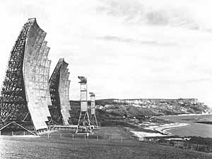
Troposcatter station at Ringstead Bay
With aerials 150 feet high, the Ringstead Bay proposal occasioned considerable local controversy, and the Air Ministry was legally challenged on whether they had the right to compulsorily purchase British land for American defence purposes. Amongst the objectors to the powerful new station was the Royal Navy, one of whose officers pointed out that it would cause ‘serious interference’ to the many RN radio stations operating around nearby Portland Bill. However, the station was built, but it was closed by 1970 and dismantled in 1974. The Ringstead-Gorramendi link provided the High Wycombe Atomic Joint Co-ordination Centre with a direct connection to US nuclear forces straddling the Mediterranean in Spain itself, Morocco, at Wheelus Field near Tripoli in Libya, and further east. In order to provide the necessary microwave link relay stations, the US Air Force obtained four more facilities at Golden Pot, near Alton, Hants, Dean Hill near Salisbury, Bulbarrow Hill near Shaftesbury, and on Portland Bill.
This would indicate that the Ringstead and Martlesham Heath links were not directly part of ACE HIGH. However, they used exactly the same technologies and frequencies.
TECHNICAL DETAILS
Frequencies used by ACE HIGH (taken from the ITU international catalogue of radio frequencies) ranged from 832.56 to 959.28MHz. The emission mode was F9 (frequency modulation, miscellaneous), and output powers typically 10kW to 50kW. Throw in the colossal antenna gain from the 80ft dishes and you can imagine the kind of power they radiated (up to 10 megawatts effective radiated power).
A stylised map of the routes inside and leaving Britain looks something like this:
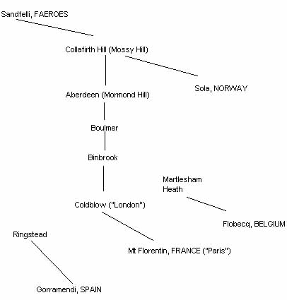
Ringstead is in Dorset, between Weymouth and Lulworth. Binbrook is in Lincs., Boulmer in Northumberland.
The station noted as Martlesham Heath (Suffolk) has nothing to do with the BT research station but was at the USAF base along the Foxhill road; it had local microwave feeders to/from Great Bromley & RAF Bentwaters. Collafirth Hill is in the Shetlands, where a branch of the network went to Sola in Norway. [Research by G4DYA and G8PTH].
Source of information: https://www.subbrit.org.uk/features/ace-high-nato-communications-system/?fbclid=IwAR1Br7dOBtBLyM9KWU0JZCWoSGIhmZJpQADljwJT42-otgATazJYoBfG9nw